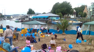
NOVA PROPOSAL 1 – Establish an annual summer ‘Bristol Beach’
This proposal is to replicate the creation of temporary ‘beaches’ which have happened in a number of European capitals over the past three or four years, starting with the ‘Paris Plage’. This was formed by closing one of the main roads alongside the River Seine, importing hundreds of tonnes of sand, making deck areas and setting up beach games, stalls, parasols, activities etc. Many cities have followed suit.
NOVA proposes that Bristol follows suit and makes a beach area for a month in the summer. Possible locations may be:
a) Cumberland Road, in front of Spike Island Studios (riverside location; will necessitate closing the road)
b) Open amphitheatre area near Lloyds Building (harbourside location)
-
c)Car park near Mud-dock (harbourside location)
UPDATE:
SUMMER 2007: UNRELATED TO THE NOVA PROPOSAL, AN URBAN BEACH IS ESTABLISHED FOR A MONTH
AT REDCLIFFE WHARF, BRISTOL , CO-ORDINATED BY DEMOS AND PARTNERS.
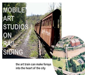
NOVA PROPOSAL 2: ‘Art Train’ Project/ Ashton Bridge
This proposal aims to set up mobile art studios, on an old train located on the Ashton Sidings, by the River Avon. The carriages/ studios will periodically be pulled across the Ashton Bridge and into the centre of the city - in front of the revamped Industrial Museum (Museum of Bristol). The studios would then be open for public viewing/ gallery sales etc.
The arrivals will be dramatic and unpredictable; and will become an important and unique cultural phenomenon in the city.
This project could go hand-in-hand with the ‘restoration’ of Ashton Swing Bridge - allowing it to take train traffic once more. The bridge is a vital link and important visual feature in the city. Yet, it is not maintained and may disintegrate unless repairs are carried out. The aging ‘relict’ quality of the bridge can be kept.
NOVA PROPOSAL 3: Celebrate the ‘Hot-Well’ & Restore/ Revisit the Sylvia Crowe Landscape Design (Cumberland Piazza, 1964)
The Bristol Hotwell first gained fame in the fifteenth century, but its greatest period was during the seventeenth and eighteenth centuries. To the Pump Room and Assembly Rooms flocked ‘a great influx of nobility and gentry from all places’ as Mathews’ Bristol Guide put it. They were said to ‘enliven and embellish the town, introduce propriety of diction, taste for literature, novelty or fashion and elegance of address, so that the inhabitants cannot fail of profiting by their arrival’. Chemical analysis of the water shows the presence of carbonic acid, nitrogen, chloride of magnesium, nitrate of magnesia, chloride of sodium, sulphates of soda, magnesium and lime, carbonates of lime, magnesia and iron, and bitumen and silica. The water was also bottled and delivered to London and various other parts of the world.
The Hotwell still rises from the riverbank near the foot of St Vincent’s Rock. The water emerges at 76 degrees Fahrenheit at around 60 gallons per minute. However, it is in a sorry state – trickling across the litter-strewn mud. This is no way to celebrate a unique part of Bristol’s history and hydro-geology.
It is proposed to launch a competition to design a piece of public art which will express the essence of the watercourse – ideally in some interactive way, and ideally allowing the public some way to feel the temperature of the water.
Nearby is the site of the early – 1960s Cumberland Piazza – designed by Sylvia Crowe, the celebrated landscape architect. NOVA proposes that this design be ‘rescued’ and part-restored as an important link-zone between Hotwells and the harbour area.
NOVA PROPOSAL 4 - Landmark And Garden @ Western Tip of Spike Island
To some extent this was (temporarily) achieved by NOVA as part of the ‘Eleven Minutes’ project (see below). However, this proposal is for a new ‘pocket park’ space & new seating zone at one of Bristol’s best (and semi-secret !) viewing points.
New ‘Belvedere’ at Western Tip of Spike Island
One of the best views of the Avon Gorge, and the magnificent Clifton Suspension Bridge, is from the (un-named) western tip of Spike Island. This is a secluded grassy spot, lying beyond the 1960’s Brunel Way. Currently not very accessible nor well-known, the point has the potential to be a significant destination on a harbour/ docklands walking route. At the point, there is a coming together of nature and industry, past and present. The builders of the huge roadway in 1964 - undoubtedly recognizing the uniqueness of the point – left behind a monument to themselves, in the form of a bulky concrete seat. This however doesn’t do justice to the spot; NOVA believes that a sensitive redesign of the space would create a new Bristol landmark – particularly appropriate to this celebratory Brunel year. This point also marks the location of the former Rownham ferry, used to cross the River Avon before the nearby bridges were built.
It is suggested that new seating be integrated with the existing landscape, which is a mix of natural riverbank and manmade dock structures and the wall of the slip-road. Materials from elsewhere in the docks can be used, and a deck or jetty structure may be added – to deal with the enormous tidal range and to heighten the drama of the location. Relevant and sensitive planting would be part of the design. We include a plan of the proposal, which also shows some additional re-modeling of some of the surrounding area. (e.g. creating a new wetland habitat in the ‘teardrop’ of the slip-road, and city gateway sculptures/ structures at the start of Plimsoll bridge.
A competition to give a name to the headland is also suggested.
NOVA's suggestion is 'Cape Verde' or 'Green Point'.
NOVA PROPOSAL 5 - Pocket Park @ Bathhust Lock
New ‘Pocket Park’, Market and Cafe at Bathurst Lock
Bathurst Lock (adjacent to the old Gaol) was sealed (with a concrete dam) during WWII, but for over a century was a major entry-point to the Floating Harbour. It was also the departure point for paddle steamers to Wales, the West Country and Ireland. Situated very close to the city centre, it is another of Bristol’s forgotten corners. Currently, part of the area is closed to the public and used for car-parking/ business; the grass area is accessible, but leaves a lot to be desired. Especially with the huge new residential development about to rise across the road, such little areas of green are essential for quality of life in the city.
NOVA proposes that the areas both sides of the lock be reclaimed for the people of Bristol and turned into a beautiful, sheltered, south-facing, sun-trapping oasis of calm. A large amount of seating can be provided on the grassy, tree-lined riverbank. Also, the paved area south of the lock would make an ideal outdoor market area. The ‘Marchioness’ Building would make a wonderful café/ restaurant location – especially if an additional deck over the river were to be added, echoing a former jetty at this location. The neglected area on the south-side of Bathurst Basin could also be incorporated into the scheme.
In addition to this basic conversion/ reclamation, we propose that new road-level viewing timber, vine-covered jetties be constructed – penetrating the existing foliage to provide viewing and gathering points on the riverside, at a higher level than the little park below. A new glass bridge could be constructed over the lock, incorporating an innovative lighting scheme and water feature. The nearby façade of the old gaol is an important heritage feature; through pedestrianisation/ traffic calming of the road, a link between gaol and pocket park could be established, creating a new waterside focus point in the city, situated on the Avon New Cut Corridor.
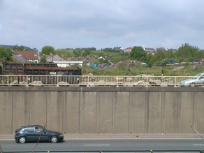
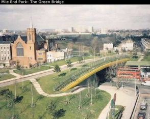
NOVA PROPOSAL 6 - Green Bridge over the M32 @ Fox Rd.
‘Green’ Bridge Link over M32 – re-connecting severed communities
This idea is based on examples from elsewhere – for example The Mile End Park Bridge in
London (pictured) and new bridges in Malmo, Sweden. These ‘bridges’ are closer to being sections of elevated park, allowing cyclists and pedestrians to cross a major divide (such as a motorway). At the same time, such bridges strongly re-connect parts of a city that have been severed through road building. In the case of Bristol, this is most acute between Easton and St Werburghs where a significant gulf exists – a situation not lost on the judges of the City of Culture bid, who commented on this as a negative issue for Bristol.
(In the early stages of the ‘City of Culture’ bid, the idea was tabled, but later dropped in favour of other infrastructure proposals)
Such a structure would add significantly to Bristol’s stature as a green/ sustainable city, and form a prominent ‘gateway’ element – making a very strong statement.
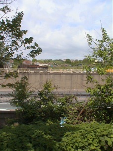
NOVA presents some photos of precedents and also location photos from the most appropriate spot at the end of the M32.
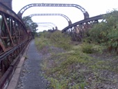
UPDATE - AUG 07
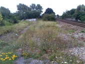
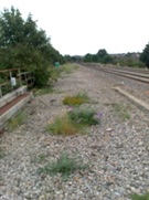
This project idea has led towards the exploration, by Friends of Fox Park, Eastside Roots and others, of a nearby disused railway bridge (for possible conversion). Also, going back in time a bit “using redundant track bed for cycle link” at this location, was proposed by consultants - David Wilson partnership - in their report on the M32 Landscape Strategy in 1999, and later (in 2003), this consultancy teamed up with Bristol East Side Traders (BEST) to investigate the Green Bridge possibilities.
UPDATE 2 - DEC ’08
Lots of renewed interest.
explorations of the route by FOFP, August 2007